
North Simcoe Rail Trail / Tiny Trail
The North Simcoe Rail Trail begins about 9 km west of Barrie and goes 30 kilometres to the Tiny Township line, just north of Elmvale. The Tiny Trail will continue the remaining 22 km to Penetanguishene and when finished the two trails together will make for a continuous distance of about 52 km.
This report was originally written in 2001, when I was first on the trail. See my 2010 update at the bottom.
The Trail 
At present you can cycle to Elmvale but only about 10 km of that distance has a new granular surface and other amenities. I began my ride at Pinegrove Road, the southern end. The improved surface actually goes about one kilometre further south, but it dead ends behind the Essa Transformer Station. It should eventually be extended another two kilometres to Simcoe Road 90. Click on map for larger copy.
From Pinegrove Road the trail goes continually downhill for almost 5 kilometres. It was not so obvious on my northward ride, but very apparent on my return trip. The grade is not steep, rail lines never are, but you do have to work a little harder going uphill. This section passes the Minesing Swamp, though the trail is on an escarpment so you look out across it rather than travel right beside it.
The trail crosses Highway 26 where there is a pavilion and parking lot. A little further north there are two farm gates, but you are allowed to open them to pass through. Be sure to close them when you are done. The chains are a little tricky and it takes a bit of fiddling to undo them.
A bit further again and the trail surface deteriorates. It is no longer a uniform granular surface and is more typically two tracks, like those left by automobiles. However I had no problem riding these surfaces on my touring bike, though my speed was a little slower. bit further again and the trail surface deteriorates. It is no longer a uniform granular surface and is more typically two tracks, like those left by automobiles. However I had no problem riding these surfaces on my touring bike, though my speed was a little slower.
Horseshoe Valley Road is the end of the developed part of the trail with gates and interpretive signs. Workmen were planting trees, a sign of continuing trail development, and I asked them how far I could continue. They said I could go to Penetanguishene if I wanted, but the surface is rougher past Elmvale.
I continued my ride and the surface was just as good as it had been for the previous 5 km. There were neither signs nor gates to discourage ATVs and trail bikes, and I saw one of each. There was even a minivan with a couple who appeared to be looking to pick berries. The minivan did not bother me but I sure do loath the noisy, smelly and speedy terrain vehicles.
Five kilometres further north is the community of Phelpston, which has a general store, a park, and strip club. For half that distance I rode on Phelpston road, which is right beside the trail. This section of trail looked rough, the road was paved and had no traffic, so I used the opportunity to travel at 25 kph rather than the 17 to 20 I had been doing. I generally like riding on granular surfaces but there is no question that rolling resistance is greater than on pavement, and you have to be a bit more cautious in case of bumps, fallen branches and wildlife.
I rode a couple of kilometres past Phelpston until my odometer told me I had cycled 20 km. The surface continued to be quite good and the scenery was very pleasant. I presume things would remain that way the remaining distance to Elmvale, about 5 km. There is however a detour between the 7th and 8th concession onto the municipal road, as the abandoned rail line has been sold off to private landowners. Similarly, at the 10th concession one must detour to Hwy 27 for a very short distance, and pick up the trail again at the intersection with County Road 6 and Hwy 27.
Trail Amenities
Along the 14 km of trail south of Horseshoe Valley Road, each road crossing has a gate along with a sign that tells the permitted uses. Motorized vehicles are prohibited (except snowmobiles in winter), walking, cycling, snowmobiling, cross-country skiing and nature observation are permitted. Rollerblading would not be practicable because the surface is not paved. I am told by the trail organizers that horseback riding will be permitted as soon as the gates are widened, and the horses will use a separate bridle path beside the main pathway. The gate openings are presently very narrow and it is awkward to manoeuver a bicycle through, so the wider gates will benefit cyclists as well.
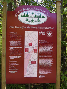
Interpretive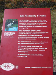 signs have been erected at select locations. There is a parking lot at Highway 26 along with a trail pavilion and picnic tables. I believe there is also an outhouse here, but there are no toilets elsewhere along the trail, nor drinking water anywhere. Refreshments can be bought at the general store in Phelpston. signs have been erected at select locations. There is a parking lot at Highway 26 along with a trail pavilion and picnic tables. I believe there is also an outhouse here, but there are no toilets elsewhere along the trail, nor drinking water anywhere. Refreshments can be bought at the general store in Phelpston.
Trail head signs with maps are installed at Pinegrove Road, Hwy 26 and Anten Mills (Horseshoe Valley Road..
Accessibility for Wheelchairs and Suitability for Children
The improved section of trail is suitable for both children and wheelchairs. Until the gates are widened they may be too narrow for wheelchairs, though. Be very careful crossing all roads, especially Hwy 26 and Horseshoe Valley Road, which have a lot of high-speed traffic. Horseshoe Valley Road is particularly hazardous because the is a hill that obscures visibility.
History
The North Simcoe Railway was built in 1878, primarily to serve the lumber business on Georgian Bay. It started from Colwell on the Toronto, Simcoe and Lake Huron Railway and ran 34 miles to Penetanguishene. It was subsequently acquired by the Grand Trunk Railway, then ultimately by Canadian National Railway.
The railway and their successors spelled Minesing incorrectly and shortened Penetanguishene to "Penetang" so it would better fit on the station sign and in timetables. Minesing station was demolished in 1963.
How to Find
From Highway 400 at Barrie drive west on County Road 90 (formerly Highway 90) for 9 kilometres to Pinegrove Road. You will know you are approaching Pinegrove Road because you will see hydro transmission towers crossing in the distance. Turn right on Pinegrove Road and drive perhaps 3 km to the trail. There is a sign on the right and it is just a few hundred metres past the CPR track, an active line. Park along the road.
You can also drive west on Highway 26 from Barrie, and park in the trail lot. From here you can take the trail either south or north. The section to the south has a longer developed trail, with the stonedust surface, but it is only about 6 km to the end which many cyclists find too short.
Your third option is to find the trail from one of the roads that cross it. You will need good maps.
2010 Update
In September, 2010, I again cycled from Pinegrove Road. This time I cycled 12.5 km to just shy of Horseshoe Valley Road (and another 12.5 km back to the car). I therefore have no update information for the trail north of Horseshoe Valley Road.
To find the Pinegrove Road starting point using a GPS, enter 3100 Pinegrove Road, Springwater, Ontario. The trail does not have an address, but 3100 is close.
The trail still does not go as far south as County Road 90. There is no outhouse at the Hwy 26 pavilion, or anywhere else. There are no longer any farm gates to negotiate north of the pavilion. The trail surface appears crude in some sections, but it is always hard-packed and easy to ride on. Watch out for occasional holes dug by wildlife, and there are two bridges where planks have been laid parallel to the direction of travel. These could be dangerous on a bicycle (similar to streetcar tracks in Toronto) so it would be advisable to walk your bike.
The trail now has limestone surface for its entire lenght to the Tiny Township line, north of Elmvale, except for the detours between the 7th and 8th Lines, and north of 10th Line. The county has a map and description here. Note the parking areas that have been provided.
Area Attractions
Fort Willow, an historical site and Conservation Area, is immediately adjacent to the trail. You can park there if you wish, and at the back descend a set of steps to the trail. The site is accessed from Grenfel Road (see map).
There are many other amenities within a short drive from the trail, including Wasaga Beach. Tourist information can be obtained at http://www.county.simcoe.on.ca/
Visitor Guide
Barrie is a city of 130,000 people and has many motels, restaurants and bike shops. You will also find services in Penetanguishene/Midland, Wasaga Beach, and to a lesser extent in Elmvale.
Circuit of Simcoe County
Rod Williamson has contributed a suggested routing for anyone wanting to do a grand circuit around much of Simcoe County. This circuit is about 150 km long and uses some of the trails mentioned on this website. To see his circuit click here .
|

