
Tay Shore Trail / Midland Rotary Waterfront Trail
The Tay Shore Trail is 16 km long from the Wye River to Waubaushene. The Midland Rotary Waterfront Trail is 8 km along the shore of Midland Bay from the Wye River into the town. They are connected to make a 24 km continuous trail. I have only cycled one km of the Midland trail so this page will focus on the Tay trail. I believe that the quality of the Midland trail is comparable. UPDATE: I am told that the trail between Waubaushene and Coldwater has been inproved with a granular surface or sand and is easy to ride now (opened August, 2012). Thanks Cecil Henry. Another readed agrees and added that the best access point in Coldwater is beside the beer store. Thanks Gary Sonnenberg.
The Trail
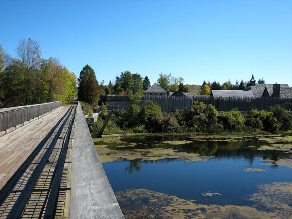 I began my ride on the west side of the Wye River and north side of Highay 12. Heading east, the old railway bridge carries users over the highway and after a very short distance another bridge crosses the Wye River. Sainte Marie Among the Hurons, a reconstructed fort, is immediately beside the trail to the right, and Martyr's Shrine can be seen across the highway to the left. Continuing eastward, the trail again crosses Highway 12 on a bridge, and after a few kilometres the traveller has the option to take a side trail 2 km into the community of Port McNicoll. Continuing instead on the main trail, you will pass the location where the Hogg Bay Tressle carried trains above our railway and the bay into Port McNicoll. The village used to be a key port for both passenger and cargo ships, and the tressle carried people and goods between the port and cities such as Toronto and Hamilton. The tressle was unfortunately demolished in 1978. I began my ride on the west side of the Wye River and north side of Highay 12. Heading east, the old railway bridge carries users over the highway and after a very short distance another bridge crosses the Wye River. Sainte Marie Among the Hurons, a reconstructed fort, is immediately beside the trail to the right, and Martyr's Shrine can be seen across the highway to the left. Continuing eastward, the trail again crosses Highway 12 on a bridge, and after a few kilometres the traveller has the option to take a side trail 2 km into the community of Port McNicoll. Continuing instead on the main trail, you will pass the location where the Hogg Bay Tressle carried trains above our railway and the bay into Port McNicoll. The village used to be a key port for both passenger and cargo ships, and the tressle carried people and goods between the port and cities such as Toronto and Hamilton. The tressle was unfortunately demolished in 1978.
Continuing eastward, there are views of Hogg Bay and you soon pass through the Village of Victoria Harbour. There are a few stores and a park very close to the trail. Further along you will get views of Sturgeon Bay and then arrive at the community of Waubaushene. The paved trail ends after passing through the village, right under the Highway 400 overpass. You will want a mountain bike if you want to go further, as the old railway roadbed has not been inproved. See Simcoe Circuit for more information.
 Nik Finney, a local to the area, tells me that they have now upgraded the trail to Coldwater. It is not paved but a good crushed limestone surface, starting under the Highway 400 overpass. "Just as it enters the village of Coldwater, it is paved and separated from the motorized trail, by a fence. There is a wonderful parking area at the end of this section with paved parking for many cars, a portable toilet, two bike stands & a fairly good information board, though the latter is missing detailed info on how to get to the next section of the Uthoff Trail going to Orillia. (The trail sections cannot currently connect because the rail properties were sold to private individuals within the village boundaries). This parking area is on the north side of Sturgeon Bay Rd, just off Hwy 12 (and Hwy 400) just as you enter the village of Coldwater." Nik Finney, a local to the area, tells me that they have now upgraded the trail to Coldwater. It is not paved but a good crushed limestone surface, starting under the Highway 400 overpass. "Just as it enters the village of Coldwater, it is paved and separated from the motorized trail, by a fence. There is a wonderful parking area at the end of this section with paved parking for many cars, a portable toilet, two bike stands & a fairly good information board, though the latter is missing detailed info on how to get to the next section of the Uthoff Trail going to Orillia. (The trail sections cannot currently connect because the rail properties were sold to private individuals within the village boundaries). This parking area is on the north side of Sturgeon Bay Rd, just off Hwy 12 (and Hwy 400) just as you enter the village of Coldwater."
Thanks for this, Nik. Returning to my original report:
I returned to my starting point then about a kilometre north along the Midland Rotary Waterfront Trail. It passes through industrial lands but I could see that it soon headed to the shore where there will be views of Midland Bay. If you travel to the end you will pass the town centre and the trail ends one or two kilometers further along. If you want to continue to Penetanguishene again see my page about the Simcoe Circuit.
 Trail Amenities Trail Amenities
The entire trail is paved. There are gates at all road crossings to discourage motorized vehicles, and a few official parking lots. There are some information signs and some benches, picnic tables and trash bins. There is one outhouse located between Victoria Harbour and Waubaushene, but it may not be there during all seasons. There are no mileage markers.
Accessibility for Wheelchairs and Suitability for Children
The trails are excellent for both. There are road crossings, mostly in the villages, so caution is urged at these locations.
History
This railway was originally chartered as the Port Hope, Lindsay and Beaverton railway in 1846, and was renamed the Midland Railway in 1869. Construction started in the Port Hope area in 1854, reached Orillia in 1873, Waubaushene two years later, and Midland in 1879. In 1884 it was leased to the Grand Trunk Railway, and in 1923 absorbed into Canadian National.
How to Find
There are many places where you can access the trails. I parked in the lot of a seemingly abandoned factory on the northwest corner of Highway 12 and Wye Valley Road. This is just east of the old railway bridge that crosses the highway, and just west of Martyrs Shrine. This is the western end of the Tay Shore Trail and the south end of the Midland Rotary Waterfront Trail. You can also find the trail easily in Victoria Harbour and Waubaushene (just head for the water and you have to cross it). Consult a map if you want to find it in Midland or elsewhere.
Maps & Guides 
Maps are available from Huronia Trails and Greenways. The Township of Tay has and excellent Map & Information Guide. Both are in PDF format. You can also click on the map at right for a copy of the HTG map.
Area Attractions
Martyrs Shrine and Ste. Marie Among the Hurons are the two most prominent attractions adjacent to the trail. Penetanguishene, a short distance north of Midland, has Discovery Harbour. There are beaches, marinas and other attractions in the vicinity.
Visitor Guide
For more tourism information in the Georgian Bay area go to VisitGeorgianBay.com.
Circuit of Simcoe County
Rod Williamson has contributed a suggested routing for anyone wanting to do a grand circuit around much of Simcoe County. This circuit is about 150 km long and uses some of the trails mentioned on this website. To see his circuit click here .
|
